Archaeological area
 The excavations at the mound in Montale began during the second part of the 19th century and were resumed over a century later in 1996, bringing to light remains from a terramare settlement. The site of the dig has been made accessible to the public in a museum form which is compatible with the natural and historical landscape.
Ditch and earthworks
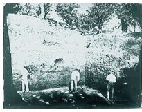
The defensive earthworks of the terramare at Montale were identified and documented in the 19th century by Carlo Boni, who set excavations in motion and was the first director of Modena’s Civic Museum.
From the notes and dig sections he left us, we can tell that their size was imposing.
Maximum width at the base of the wall was at least ten metres. It rose to a height of two metres, even if the original elevation must have been still higher, further heightened by a palisade that probably surmounted it.
During 19th century excavations, however, the ditch was not identified. It was not until recent research was carried out that the full size of the ditch was revealed: at some points it reached a width of over 35 metres, while its depth was about three metres below the level of the surrounding countryside.
Excavation area
Originally, the Montale terramare extended over an area of about one hectare, excluding the ditch that ran round the entire village.
Traces of fortifications have been identified in the archaeological area, and the section uncovered by the 1996-2001 excavations was transformed into a museum where an archaeological vertical section or stratigraph over three metres high can be observed. A single horizontal stratum has also been exposed. Both were created using casts perfectly similar to the original surfaces, it being impossible, for conservation reasons, to expose organic remains made of wood.
The excavations revealed an extremely complex stratigraph which allowed researchers to reconstruct the various phases in the life of the village, thanks also to the discovery of numerous wooded remains from the dwellings. The remains of five successive dwellings were uncovered, as well as a granary and a workshop for extracting and crafting metals. Given the abundance of structural data related to the earliest period of the village, phases 1 and 2, it was possible to extrapolate a plan of two dwellings and reconstruct them in the open-air museum.
Dating was obtained by examining archaeological materials and by radiocarbon analysis, which revealed that the Montale terramare occupied a time-span between the Middle Bronze 2 and the Recent Bronze 1, in other words between the XVIth and beginning of the XIIIth century BC.
The data from the excavations are producing an impressive body of scientific information on both archaeological aspects but also on the economic life and the environment of a terramare.
Thanks to specialist research, it has been possible to reconstruct the climatic and environmental situation and deduce that the community in Montale depended for its survival on a comparatively advanced form of farming based on cereals and legumes, in addition to keeping goats, pigs and cattle.
The archaeological finds feature mainly pottery, though numerous bronze, deer-horn and amber objects have also been uncovered. Wooden objects are of particular significance and include a plough, the remains of a bow, a knife and the handle of a scythe.
Traces of the ditch and earthworks
During the early 12th century, a castle stood on the mound whose foundation perhaps dates back to a previous age.
Remains of the castle walls were uncovered beneath what is now the parish house. These include traces of a tower and the perimeter wall which ran round the outside of the terramare earthworks. The bell-tower of the present church may well be built where the castle’s main tower once rose.
